Table 6.68—DRM_Continuous_Level_Of_Detail_Related_Geometry
|
Property |
Description |
|||||||||
|
Superclass |
||||||||||
|
Class |
· <DRM Continuous Level Of Detail Related Geometry> |
|||||||||
|
Subclass |
· none |
|||||||||
|
Definition |
An object of this class is used to represent continuous terrain or continuous adaptive terrain, by replacing a <DRM Polygon> with a set of fragmented <DRM Polygon>s that represent the terrain at a finer level of detail at close range (or alternatively, with a coarser level of detail at long range). The general idea is that basic <DRM Polygon>s have fragmented <DRM Polygon>s within them, and those <DRM Polygon>s may have subsequent fragmentation. |
|||||||||
|
Example(s) |
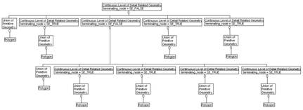
· A Continuous LOD node can be fragmented into one or more <DRM Polygon>s, and will then have zero or more Continuous LOD nodes as subnodes. Any Continuous LOD node that contains Continuous LOD nodes under it will have the terminating_node flag set to FALSE. The <DRM Union Of Primitive Geometry> node will contain <DRM Polygon> data. If a Continuous LOD node is encountered with the terminating_node flag set to TRUE, that means it only has a <DRM Union Of Primitive Geometry> node under it.
(Note that this example only shows two levels of polygon fragmentation. Each <DRM Continuous Level Of Detail Related Geometry> could contain component <DRM Continuous Level Of Detail Related Geometry>s, but that would make a huge picture. Only the idea is represented here.) |
|||||||||
|
Inherited field elements |
|
|||||||||
|
Field elements |
|
|||||||||
|
Associated to (one-way) (inherited) |
· none |
|||||||||
|
Associated to (one-way) |
· none |
|||||||||
|
Associated by (one-way) (inherited) |
· zero or one <DRM Hierarchy Summary Item> · zero or more <DRM Reference Surface>s |
|||||||||
|
Associated by (one-way) |
· none |
|||||||||
|
Associated with (two-way) (inherited) |
· zero or more <DRM Feature>s · zero or more <DRM Geometry Hierarchy>s |
|||||||||
|
Associated with (two-way) |
· none |
|||||||||
|
Composed of (two-way) (inherited) |
· zero or more {ordered} <DRM Attribute Set Index>s · zero or one <DRM Bounding Volume> · zero or one <DRM Centre Of Buoyancy> · zero or one <DRM Centre Of Mass> · zero or one <DRM Centre Of Pressure> · zero or one <DRM Classification Data> · zero or more <DRM Collision Volume>s · zero or more {ordered} <DRM Colour>s · zero or one <DRM Conformal Behaviour> · zero or more <DRM Geometry Topology Hierarchy>s · zero or more <DRM Hierarchical Table>s · zero or more {ordered} <DRM Image Mapping Function>s · zero or one <DRM Light Rendering Properties> · zero or more <DRM Light Source>s · zero or one <DRM LSR Transformation> · zero or one <DRM Overload Priority Index> · zero or one <DRM Perimeter Data> · zero or one <DRM Presentation Domain> · zero or more <DRM Property Description>s · zero or more <DRM Property Table>s · zero or more <DRM Property Table Reference>s · zero or more <DRM Property Value>s · zero or one <DRM Reference Surface> · zero or one <DRM Rendering Priority Level> · zero or one <DRM Rendering Properties> · zero or more <DRM Sound Instance>s · zero or one <DRM Spatial Domain> · zero or one <DRM Stamp Behaviour> · zero or one <DRM Time Constraints Data> |
|||||||||
|
Composed of (two-way) |
· one <DRM Union Of Primitive Geometry> · zero or more <DRM Continuous Level Of Detail Related Geometry>s |
|||||||||
|
Composed of (two-way metadata) (inherited) |
· zero or one <DRM Access> · zero or more <DRM Browse Media>s · zero or one <DRM Citation> · zero or more <DRM Cross Reference>s · zero or one <DRM Data Quality> · zero or one <DRM Description> · zero or one <DRM Keywords> · zero or one <DRM Point Of Contact> |
|||||||||
|
Composed of (two-way metadata) |
· none |
|||||||||
|
Component of (two-way) (inherited) |
· zero or more <DRM Alternate Hierarchy Related Geometry>s through <DRM Hierarchy Data>s · zero or more <DRM Animation Related Geometry>s · zero or more <DRM Classification Related Geometry>s through <DRM Classification Data>s · zero or one <DRM Environment Root> · zero or one <DRM Geometry Model> · zero or more <DRM Level Of Detail Related Geometry>s through <DRM Base Level Of Detail Data>s · zero or more <DRM Oct Tree Related Geometry>s through <DRM Oct Tree Data>s · zero or more <DRM Perimeter Related Geometry>s through <DRM Perimeter Data>s · zero or more <DRM Quad Tree Related Geometry>s through <DRM Quad Tree Data>s · zero or more <DRM Separating Plane Relations>s through <DRM Separating Plane Data>s · zero or more <DRM Spatial Index Related Geometry>s through <DRM Spatial Index Data>s · zero or more <DRM State Related Geometry>s through <DRM State Data>s · zero or more <DRM Time Related Geometry>s through <DRM Time Constraints Data>s · zero or more <DRM Union Of Geometry Hierarchy>s |
|||||||||
|
Component of (two-way) |
· zero or one <DRM Continuous Level Of Detail Related Geometry> |
|||||||||
|
Constraints |
||||||||||
|
Notes |
1 If TRUE, for any object that exists 'below' this aggregation, each object will appear in only one 'branch' of this aggregation. If FALSE, objects may appear in multiple 'branches' of this aggregation. 2 If TRUE, each 'branch' strictly follows the rules of this aggregation. If FALSE, each 'branch' might bend the rules a bit. For example, if this is a spatial aggregation, a value of TRUE indicates that objects will not cross the spatial extents defined by this aggregation relationship, and a value of FALSE indicates that objects might cross those bounds. For another example, if this is a time-based aggregation, a value of TRUE indicates that all branches will only contain data valid for the times specified for each branch, and a value of FALSE indicates that the branches have the option of including data that falls outside of the specified time ranges for that branch. 3 This flag identifies if the current level is the lowest level of fragmentation for a specific chain. Set to TRUE if no other <DRM Continuous Level of Detail Related Geometry> nodes are found below this chain's current level. |
|||||||||
|
Class diagram |