Table 6.269—DRM_Spatial_Index_Related_Geometry
|
Property |
Description |
|||||||||||||||||||||
|
Superclass |
||||||||||||||||||||||
|
Class |
· <DRM Spatial Index Related Geometry> |
|||||||||||||||||||||
|
Subclass |
· none |
|||||||||||||||||||||
|
Definition |
An object of this DRM class specifies an aggregation of <DRM Geometry Hierarchy> in which each component <DRM Geometry Hierarchy> represents a different tile within a spatially indexed (tiled) organization of <DRM Primitive Geometry> objects within a SEDRIS transmittal. The <DRM Spatial Index Data> link object attached to each component <DRM Geometry Hierarchy> indicates the tile that it represents. |
|||||||||||||||||||||
|
Example(s) |
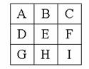
· Consider an <DRM Environment Root> describing a terrain surface that is a mix of grids and <DRM Polygon>s, organized by spatial indexing into 9 cells.
All cells except H are grids (represented in SEDRIS as <DRM Property Grid>s) captured at 1 level of detail. Cell H consists of <DRM Polygon>s.
Note that the components of the <DRM Spatial Index Related Geometry> are not ordered; the <DRM Spatial Index Data> is used to identify the individual tiles. |
|||||||||||||||||||||
|
Inherited field elements |
|
|||||||||||||||||||||
|
Field elements |
|
|||||||||||||||||||||
|
Associated to (one-way) (inherited) |
· none |
|||||||||||||||||||||
|
Associated to (one-way) |
· none |
|||||||||||||||||||||
|
Associated by (one-way) (inherited) |
· zero or one <DRM Hierarchy Summary Item> · zero or more <DRM Reference Surface>s |
|||||||||||||||||||||
|
Associated by (one-way) |
· none |
|||||||||||||||||||||
|
Associated with (two-way) (inherited) |
· zero or more <DRM Feature>s · zero or more <DRM Geometry Hierarchy>s |
|||||||||||||||||||||
|
Associated with (two-way) |
· none |
|||||||||||||||||||||
|
Composed of (two-way) (inherited) |
· zero or more {ordered} <DRM Attribute Set Index>s · zero or more <DRM Base Level Of Detail Data> · zero or one <DRM Bounding Volume> · zero or one <DRM Centre Of Buoyancy> · zero or one <DRM Centre Of Mass> · zero or one <DRM Centre Of Pressure> · zero or one <DRM Classification Data> · zero or more <DRM Collision Volume>s · zero or more {ordered} <DRM Colour>s · zero or one <DRM Conformal Behaviour> · zero or more <DRM Geometry Topology Hierarchy> · zero or more <DRM Hierarchical Table>s · zero or more {ordered} <DRM Image Mapping Function>s · zero or one <DRM Light Rendering Properties> · zero or more <DRM Light Source>s · zero or one <DRM LSR Transformation> · zero or one <DRM Overload Priority Index> · zero or one <DRM Perimeter Data> · zero or one <DRM Point Of Contact> · zero or one <DRM Presentation Domain> · zero or more <DRM Property Description>s · zero or more <DRM Property Table>s · zero or more <DRM Property Table Reference>s · zero or more <DRM Property Value>s · zero or one <DRM Reference Surface> · zero or one <DRM Rendering Priority Level> · zero or one <DRM Rendering Properties> · zero or more <DRM Sound Instance>s · zero or one <DRM Spatial Domain> · zero or one <DRM Stamp Behaviour> · zero or one <DRM Time Constraints Data> |
|||||||||||||||||||||
|
Composed of (two-way) |
· one or more <DRM Geometry Hierarchy>s through <DRM Spatial Index Data> · one <DRM Location>6 |
|||||||||||||||||||||
|
Composed of (two-way metadata) (inherited) |
· zero or one <DRM Access> · zero or more <DRM Browse Media>s · zero or one <DRM Citation> · zero or more <DRM Cross Reference>s · zero or one <DRM Data Quality> · zero or one <DRM Description> · zero or one <DRM Keywords> · zero or one <DRM Point Of Contact> |
|||||||||||||||||||||
|
Composed of (two-way metadata) |
· none |
|||||||||||||||||||||
|
Component of (two-way) (inherited) |
· zero or more <DRM Alternate Hierarchy Related Geometry>s through <DRM Hierarchy Data>s · zero or more <DRM Animation Related Geometry>s · zero or more <DRM Classification Related Geometry>s through <DRM Classification Data>s · zero or one <DRM Environment Root> · zero or one <DRM Geometry Model> · zero or more <DRM Level Of Detail Related Geometry>s through <DRM Base Level Of Detail Data>s · zero or more <DRM Oct Tree Related Geometry>s through <DRM Oct Tree Data>s · zero or more <DRM Perimeter Related Geometry>s through <DRM Perimeter Data>s · zero or more <DRM Quad Tree Related Geometry>s through <DRM Quad Tree Data>s · zero or more <DRM Separating Plane Relations>s through <DRM Separating Plane Data>s · zero or more <DRM Spatial Index Related Geometry>s through <DRM Spatial Index Data>s · zero or more <DRM State Related Geometry>s through <DRM State Data>s · zero or more <DRM Time Related Geometry>s through <DRM Time Constraints Data>s · zero or more <DRM Union Of Geometry Hierarchy>s |
|||||||||||||||||||||
|
Component of (two-way) |
· none |
|||||||||||||||||||||
|
Constraints |
· Image mapping functions and texture coordinates |
|||||||||||||||||||||
|
Notes |
1 If TRUE, for any object that exists 'below' this aggregation, each object will appear in only one 'branch' of this aggregation. If FALSE, objects may appear in multiple 'branches' of this aggregation. 2 If TRUE, each 'branch' strictly follows the rules of this aggregation. If FALSE, each 'branch' might bend the rules a bit. For example, if this is a spatial aggregation, a value of TRUE indicates that objects will not cross the spatial extents defined by this aggregation relationship, and a value of FALSE indicates that objects might cross those bounds. For another example, if this is a time-based aggregation, a value of TRUE indicates that all branches will only contain data valid for the times specified for each branch, and a value of FALSE indicates that the branches have the option of including data that falls outside of the specified time ranges for that branch. 3 If FALSE, all column and row entries (all expected Feature Hierarchy components) are present. If TRUE, one or more entries are not present. 4 Length of a cell in the given units along the X axis. 5 Length of a cell in the given units along the Y axis. 6 The origin of the collection. The lower-left corner. |
|||||||||||||||||||||
|
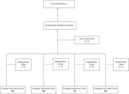
Class diagram |