Table 6.228—DRM_Reference_Surface
|
Property |
Description |
||||||||||||
|
Superclass |
|||||||||||||
|
Class |
· <DRM Reference Surface> |
||||||||||||
|
Subclass |
· none |
||||||||||||
|
Definition |
A <DRM Reference Surface> specifies, for the hierarchy instance(s) of which it is a component, a surface which is to be used to resolve the elevation of <DRM Location 2D> instances in the component tree rooted at each hierarchy instance. In addition, a <DRM Reference Surface> specifies how the surface is to be used in the resolution process. |
||||||||||||
|
Example(s) |
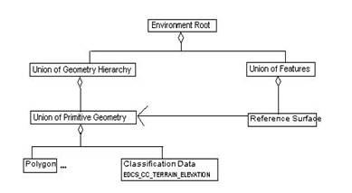
· An <DRM Environment Root> has both a <DRM Union Of Geometry Hierarchy> and a <DRM Union Of Features> component. The <DRM Union Of Geometry Hierarchy> contains a <DRM Union Of Primitive Geometry> with a <DRM Classification Data> (specifying TERRAIN_ELEVATION). This <DRM Union Of Primitive Geometry> contains <DRM Polygon>s, which inherit the <DRM Classification Data>. The <DRM Union Of Features> has a <DRM Reference Surface> component, which associates to the <DRM Union Of Primitive Geometry> and has these field values: multiplicity_rule = HIGHEST; classification = TERRAIN_ELEVATION; lod_rule = ALL_LOD.
<DRM Location 2D> instances found in the <DRM Union Of Features> aggregation tree use the terrain polygons to resolve elevation. · Continuing example 1, the <DRM Union Of Geometry Hierarchy> under the <DRM Environment Root> contains another <DRM Union Of Primitive Geometry> with <DRM Polygon>s classified as INLAND_WATER_ELEVATION. The <DRM Union Of Features>aggregates a <DRM Union Of Features>, which is classified as ENGINEERING_BRIDGE and contains <DRM Linear Features> using <DRM Location 2D> instances. The <DRM Union Of Features> also contains a <DRM Reference Surface> with <DRM Classification Data> tagged as INLAND_WATER_ELEVATION, and associated to the <DRM Union Of Primitive Geometry>. · Consider as the <DRM Reference Surface>'s geometry, a <DRM Spatial Index Related Geometry> whose components are all <DRM Classification Related Geometry>. Each <DRM Classification Related Geometry> contains three <DRM Union Of Primitive Geometry> objects: one for terrain surface polygons, one for road polygons (which may or may not be part of the road surface), and one for forest canopy polygons. The <DRM Reference Surface> would associate to the <DRM Spatial Index Related Geometry>, and its classification field would be set to TERRAIN_ELEVATION. The resolution process then ignores the road and canopy polygons, but sees all the terrain polygons regardless of in which union they are. Consider a <DRM Linear Feature> representing a road, which mostly stays on the road geometry but sometimes strays off. This <DRM Linear Features> is placed in a sub-<DRM Union Of Features> aggregating a different <DRM Reference Surface> object, which associates to the same <DRM Spatial Index Related Geometry> but has classification = ROAD. The resolution process for this <DRM Reference Surface> sees the road <DRM Polygon>s and ignores the others. For <DRM Feature Node>s that stray off the road, the corresponding <DRM Location 2D>s' rays will fail to intersect any road polygon, so we are in case 3: empty intersection set. We then fall back to the previous override, which was the terrain surface. · Using a specific plane for elevation resolution, such as a carrier deck, or a landing plate. Represent the plane with one or more <DRM Polygon>s. Put these A CLASS="Polygon">Polygons under a <DRM Union Of Primitive Geometry> and classify them. Use that <DRM Union Of Primitive Geometry> for the <DRM Reference Surface> associated <DRM Geometry Hierarchy>, and use the same classification for the classification field. · Terrain is organized in 3 minute regions, which are grouped into 1 degree cells, where the 1 degree cells are collected under one <DRM Union Of Geometry Hierarchy>. In addition, <DRM Feature> and non-terrain <DRM Geometry> are organized under a corresponding spatial organization. Each 3 minute hierarchy has a <DRM Reference Surface> associated to the corresponding 3 minute terrain. Each 1 degree hierarchy has a <DRM Reference Surface> associated to the corresponding 1 degree terrain. Each of the highest level feature and non-terrain geometry hierarchies has a <DRM Reference Surface> associated to the terrain <DRM Union Of Geometry Hierarchy>. In this scheme, a <DRM Location 2D> in a 3 minute region finds its resolution surface in the corresponding 3 minute terrain. If a <DRM Location 2D> "strays" outside its region (i.e., strict_organizing_principle=FALSE), then the containing 1 degree terrain resolves the <DRM Location 2D>. If the location ray fails to intersect the 1 degree surface, then the full terrain <DRM Union Of Geometry Hierarchy> is used. If ray/surface intersection still fails, the elevation is resolved by the vertical datum. |
||||||||||||
|
Inherited field elements |
|
||||||||||||
|
Field elements |
|
||||||||||||
|
Associated to (one-way) (inherited) |
· none |
||||||||||||
|
Associated to (one-way) |
· one <DRM Geometry Hierarchy>4 |
||||||||||||
|
Associated by (one-way) (inherited) |
· none |
||||||||||||
|
Associated by (one-way) |
· one <DRM Geometry Hierarchy>4 |
||||||||||||
|
Associated with (two-way) (inherited) |
· none |
||||||||||||
|
Associated with (two-way) |
· none |
||||||||||||
|
Composed of (two-way) (inherited) |
· none |
||||||||||||
|
Composed of (two-way) |
· zero or more <DRM Property Value>5 |
||||||||||||
|
Composed of (two-way metadata) (inherited) |
· none |
||||||||||||
|
Composed of (two-way metadata) |
· none |
||||||||||||
|
Component of (two-way) (inherited) |
· none |
||||||||||||
|
Component of (two-way) |
· zero or more <DRM Feature Hierarchy>s · zero or more <DRM Geometry Hierarchy>s |
||||||||||||
|
Constraints |
· Environment_Root spatial reference frame · Image_Anchor spatial reference frame |
||||||||||||
|
Notes |
1 Within the resolution surface, use only geometry matching this (possibly elaborated) classification. 2 Rule to select a single point from multiple intersections of a ray with a resolution surface. 3 Rule to select one LOD branch. 4 Specifies the <DRM Geometry Hierarchy> containing the <DRM Surface Geometry> and/or <DRM Property Grid>s to be used as the resolution surface. 5 Provided only when the classification requires elaboration by <DRM Property Value>. |
||||||||||||
|
Class diagram |