Table 6.268—DRM_Spatial_Index_Related_Features
|
Property |
Description |
|||||||||||||||||||||
|
Superclass |
||||||||||||||||||||||
|
Class |
· <DRM Spatial Index Related Features> |
|||||||||||||||||||||
|
Subclass |
· none |
|||||||||||||||||||||
|
Definition |
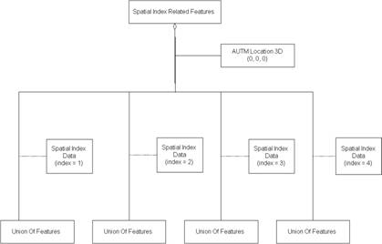
An object of this DRM class specifies an aggregation of <DRM Feature Hierarchy>s in which each component <DRM Feature Hierarchy> represents a different tile within a spatially indexed (tiled) organization of <DRM Primitive Feature> objects within a SEDRIS transmittal. The <DRM Spatial Index Data> link object attached to each component <DRM Feature Hierarchy> indicates the tile that it represents. |
|||||||||||||||||||||
|
Example(s) |
· Consider a with row_count = 1, column_count = 4, row_width = 1000 metres, column_width = 500 metres. For simplicity, each of the 4 branches of the in this example is a <DRM Union Of Features>.
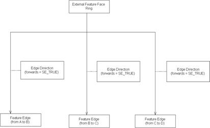
Since the origin of the collection (its lower-left corner, the <DRM AUTM Location 3D> is (0, 0, 0), the coverages of the branches are: from (0, 0) to (500, 1000) from (500, 0) to (1000, 1000) from (1000, 0) to (1500, 1000) from (1500, 0) to (2000, 1000) (Note that a <DRM Spatial Index Related Features> does not specify the range of z/height/elevation values.) Consider a triangular <DRM Areal Feature> in branch #2 of this aggregation, consisting of one <DRM Regular Feature Face>, which in turn has an <DRM External Feature Face Ring> instance containing three <DRM Feature Edge> as follows:
Since the areal feature crosses the boundary between branch #2 and branch #3, the strict_organizing_principle of the <DRM Spatial Index Related Features> shall be set to FALSE. |
|||||||||||||||||||||
|
Inherited field elements |
|
|||||||||||||||||||||
|
Field elements |
|
|||||||||||||||||||||
|
Associated to (one-way) (inherited) |
· none |
|||||||||||||||||||||
|
Associated to (one-way) |
· none |
|||||||||||||||||||||
|
Associated by (one-way) (inherited) |
· zero or one <DRM Hierarchy Summary Item> |
|||||||||||||||||||||
|
Associated by (one-way) |
· none |
|||||||||||||||||||||
|
Associated with (two-way) (inherited) |
· zero or more <DRM Feature>s · zero or more <DRM Geometry Hierarchy>s · zero or more <DRM Property Grid>s |
|||||||||||||||||||||
|
Associated with (two-way) |
· none |
|||||||||||||||||||||
|
Composed of (two-way) (inherited) |
· zero or more {ordered} <DRM Attribute Set Index>s · zero or more <DRM Base Level Of Detail Data> · zero or one <DRM Classification Data> · zero or more <DRM Colour>s · zero or more <DRM Feature Topology Hierarchy> · zero or more {ordered} <DRM Image Mapping Function>s6 · zero or more <DRM Label>s · zero or one <DRM Perimeter Data> · zero or one <DRM Point Of Contact> · zero or one <DRM Presentation Domain>7 · zero or more <DRM Property Description>s · zero or more <DRM Property Table>s · zero or more <DRM Property Table Reference>s · zero or more <DRM Property Value>s · zero or one <DRM Reference Surface> · zero or one <DRM Rendering Priority Level> · zero or more <DRM Sound Instance>s · zero or one <DRM Spatial Domain> · zero or one <DRM Time Constraints Data> |
|||||||||||||||||||||
|
Composed of (two-way) |
· one <DRM Location>8 · one or more <DRM Feature Hierarchy>s through <DRM Spatial Index Data> |
|||||||||||||||||||||
|
Composed of (two-way metadata) (inherited) |
· zero or one <DRM Access> · zero or more <DRM Browse Media>s · zero or one <DRM Citation> · zero or more <DRM Cross Reference>s · zero or one <DRM Data Quality> · zero or one <DRM Description> · zero or one <DRM Keywords> · zero or one <DRM Point Of Contact> |
|||||||||||||||||||||
|
Composed of (two-way metadata) |
· none |
|||||||||||||||||||||
|
Component of (two-way) (inherited) |
· zero or more <DRM Alternate Hierarchy Related Features>s through <DRM Hierarchy Data>s · zero or more <DRM Classification Related Features>s through <DRM Classification Data>s · zero or one <DRM Environment Root> · zero or one <DRM Feature Model> · zero or more <DRM Level Of Detail Related Features>s through <DRM Base Level Of Detail Data>s · zero or more <DRM Oct Tree Related Features>s through <DRM Oct Tree Data>s · zero or more <DRM Perimeter Related Features>s through <DRM Perimeter Data>s · zero or more <DRM Quad Tree Related Features>s through <DRM Quad Tree Data>s · zero or more <DRM Spatial Index Related Features>s through <DRM Spatial Index Data>s · zero or more <DRM State Related Features>s through <DRM State Data>s · zero or more <DRM Time Related Features>s through <DRM Time Constraints Data>s · zero or more <DRM Union Of Features>s |
|||||||||||||||||||||
|
Component of (two-way) |
· none |
|||||||||||||||||||||
|
Constraints |
· Image mapping functions and texture coordinates |
|||||||||||||||||||||
|
Notes |
1 If TRUE, for any object that exists 'below' this aggregation, each object will appear in only one 'branch' of this aggregation. If FALSE, objects may appear in multiple 'branches' of this aggregation. 2 If TRUE, each 'branch' strictly follows the rules of this aggregation. If FALSE, each 'branch' might bend the rules a bit. For example, if this is a spatial aggregation, a value of TRUE indicates that objects will not cross the spatial extents defined by this aggregation relationship, and a value of FALSE indicates that objects might cross those bounds. For another example, if this is a time-based aggregation, a value of TRUE indicates that all branches will only contain data valid for the times specified for each branch, and a value of FALSE indicates that the branches have the option of including data that falls outside of the specified time ranges for that branch. 3 If FALSE, all column and row entries (all expected <DRM Feature Hierarchy> components) are present. If TRUE, one or more entries are not present. 4 Length of a cell in the given units along the X axis. 5 Length of a cell in the given units along the Y axis. 6 Provided to support "attributes for derived objects." That is, these components are used only to specify texture mapping information for geometry that is derived from the <DRM Feature> by the consumer. These <DRM Image Mapping Functions> shall use <DRM Image Anchor> components to specify the mapping. 7 This is needed because in many cases, an <DRM Aggregate Feature> may be significant only for a particular domain, e.g. radar. 8 The origin of the collection. The lower-left corner. |
|||||||||||||||||||||
|
Class diagram |